Thursday, September 16, 2010

A Brief History of Smith Level Road

Long before the Town of Carrboro and even before UNC, there was a road that connected Hillsborough to the town at the limits of navigation on the Cape Fear River – the nearest inland port – then called Cross Creek but now called Fayetteville. That road ran high up in the watershed of New Hope, Bolin and Morgan Creeks, just a mile west of the New Hope Chapel for which Chapel Hill is named. That road is Old NC 86/Old Fayetteville Road/Ray Road/Smith Level Road.

Though the old Fayetteville road is not named on John Daniel’s 1792 survey of the proeprties donated to start UNC, the road is nevertheless plainly shown:

Daniel Map 1792 Smith Level

The part of the road where it crossed Morgan Creek is now gone, but there used to be a bridge there. The last remains of that bridge are still there, a single steel rail still spanning the creek. The bridge was nearly directly at the McCauley Mill on Morgan Creek. The University Lake Dam stands on the same site that the McCauley Mill dam did.

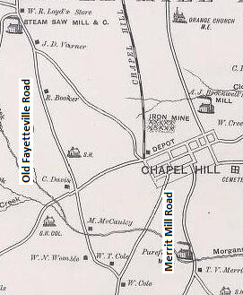
When George W. Tate produced the first detailed map of Orange County in 1891 he showed largely the same road configuration:

Smith level

However the McCauley bridge site was abandoned in the 1920’s (probably about the same time the mill was abandoned) in favor of another old bridge location a little further down stream (where the present bridge is). South Greensboro Street was not extended down the hill to that location until the 1950’s sometime, but Old Pittsboro Road in Carrboro wended its way down to meet Merritt Mill Road and cross Morgan Creek. The present bridge location had been long in use and is also shown on the 1792 Daniel plat. Before the University was built an alignment more or less equivalent to Cameron Avenue/Merritt Mill Road/Smith Level Road lead from the old Fayetteville road up to the New Hope Chapel (which formerly stood where the Carolina Inn is today).

Probably since the 19th century, this road has been called Smith Level Road after the Smith family farm which was along it. The Smith house is that stately home on the west side of Smith Level Road, about 2/3 of the way to Chatham County from Carrboro. It was once the home of Sidney Smith a white slave owner whose African American descendants include Pauli Murray. The road is called Smith Level because of the flat topography particularly on the southern half of the road.

In fact the unusually flat topography is the very reason the old Fayetteville road ran that way. Considering the inherent advantages of the route and the fact that Hillsborough was the site of a Native American village from pre-Columbian times, it is conceivable that the route from Hillsborough down Old NC 86/Old Fayetteville Road/Ray Road/Smith Level Road may well have been a Native American trade route from long ago.

THE FUTURE OF SMITH LEVEL ROAD

The future of Smith Level Road is an opportunity for our community. I believe we need to work on ways to improve bicycle and pedestrian facilities along the parts of Smith Level Road that are in town. The more rural character near and south of Damascus Church Road does not seem well suited to sidewalks and bike lanes, but perhaps working with OWASA and Orange County we can find a way to create a separate greenway – mostly on University Lake property – to connect Carrboro with Heritage Hills and Star Point. At the same time, Chapel Hill has plans for future bike/ped connections from Southern Village to Smith Level Road.

The current proposal from NCDOT widens the overall profile of Smith Level Road by adding sidewalks bike lanes, and a center median, but only one travel lane in each direction. The plan would connect the bridge over Morgan Creek with Rock Haven Road and Carrboro High School with sidwalks. It would add sidewalks on the last part of Culbreth Road from the end of the existing sidewalks on around the corner onto Smith Level Road. The plan includes crosswalks at several points and it also has a roundabout at the Rock Haven Road intersection in order to slow down commuters, trucks and high school students alike.

I concede that this plan is wider than I would like it to be and although I am not convinced that a center median is essential, NCDOT is adamanat about it. The effect of the median is to force some cutting into the woods on the west side of the project, but with DOT’s latest revisions very little new Right-of-Way will need to be condemned. The plan will restrict people from turning left out Willow Oak Lane in the Berryhill neighborhood, but traffic can turn right out of there to access Culbreth Road or those driving downtown can exit the neighborhood further south on Orchard Lane and BPW Club Road.

While some Berryhill residents have made the point that they will have to drive further in order to reach UNC or downtown because of the change, I submit that this sacrifice is modest compared to the benefits that accrue to our whole community from the bicycle and pedestrian improvements we get on Smith Level Road. Indeed the net result will make it a little harder for Berryhill residents to drive downtown, but a good deal easier for the same folks to walk or bike downtown.

You can let the Carrboro Board of Aldermen know what you think by emailing your opinion to MayorChilton@gmail.com. BE ADVISED: We are required by state law to give copies of all such emails to the local media.